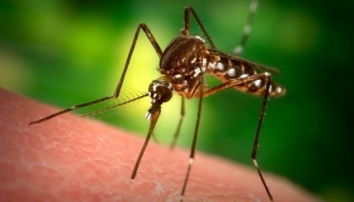
The first ever map about dengue vulnerability published on Tuesday and it makers interesting reading. Major parts of Europe, West and Central Africa and South America face the risk of dengue epidemic as a result of climate change and rapid urbanization. The United Nations University has released a map pinpointing vulnerable areas as a tool to help prevent outbreaks. Research found that dengue fever which is spread by the bite of mosquitoes is spreading.
The report said climate changes has led to increased exposure and is a threat to areas which never had any Dengue outbreak in the past. The report warns that as the global temperatures rise, dengue can spread to large parts of Europe and South America which are too frigid and cold to sustain mosquito population.
Dengue is also expected to spread in Central and West Africa where sanitation and healthcare services are very poor. The map reveals the ebb and fall of dengue vulnerabilities throughout the year. It also illustrates the hot spots and locations where the danger of dengue epidemic is high so that countries can set up surveillance.
Corinne Schuster-Wallace, senior researcher at the UN University, told the Thomson Reuters Foundation in a phone interview from Canada, “We’ve seen from Ebola that in this global world that we’re living in those infectious diseases can travel around. The conditions for these diseases are dynamic over time and given that we’re changing our social and environmental dynamics, the global distribution of these infectious diseases like dengue is going to change.”
According to latest figures released by WHO, Dengue kills an estimated 20,000 people each year and infects up to 100 million. Experts also say that the real numbers could be three times the WHO estimate. There is no vaccine for dengue. The current approach is to control the population of Mosquitoes which carry the virus.
Leave a Reply
You must be logged in to post a comment.